Does a downtown block generate more tax revenue than a strip mall?
The Chemung County data has a clear answer — and it matters for how the county
spends money on roads, water, and sewers for decades to come.
The Simple Version
Before the charts and the numbers, here is the idea in plain terms.
Every road, water pipe, and sewer line costs money to build and maintain.
That cost doesn't care how much the building at the end of it is worth —
a mile of pipe is a mile of pipe.
So the real question isn't "how much tax does this property pay?" It's
"how much tax does it pay compared to how much infrastructure it needs?"
A four-story apartment building on a 50-foot-wide downtown lot shares one
water connection, one stretch of sidewalk, one section of road — across
dozens of residents and businesses. A Walmart on 17 acres needs 17 acres
worth of roads, parking lot drainage, water mains, and emergency response
coverage — all for one store.
The question this page answers: does the downtown block actually pay
more per foot of road and pipe than the big box? In Chemung County,
the answer is yes — by a significant margin.
The Theory
Strong Towns is a national organization arguing that cities have spent decades
building suburban roads and utilities that can never generate enough tax revenue
to pay for their own upkeep.
The core claim: A downtown building on a narrow lot generates
more tax revenue per foot of road frontage — and per acre of land — than a
big-box store surrounded by parking. Every foot of street frontage requires
roughly one foot of road, curb, sidewalk, water main, and sewer line to serve it.
A 50-ft-wide downtown building shares that infrastructure cost across multiple
floors and many uses. A 600-ft-wide parking lot spreads it across one story
of retail.
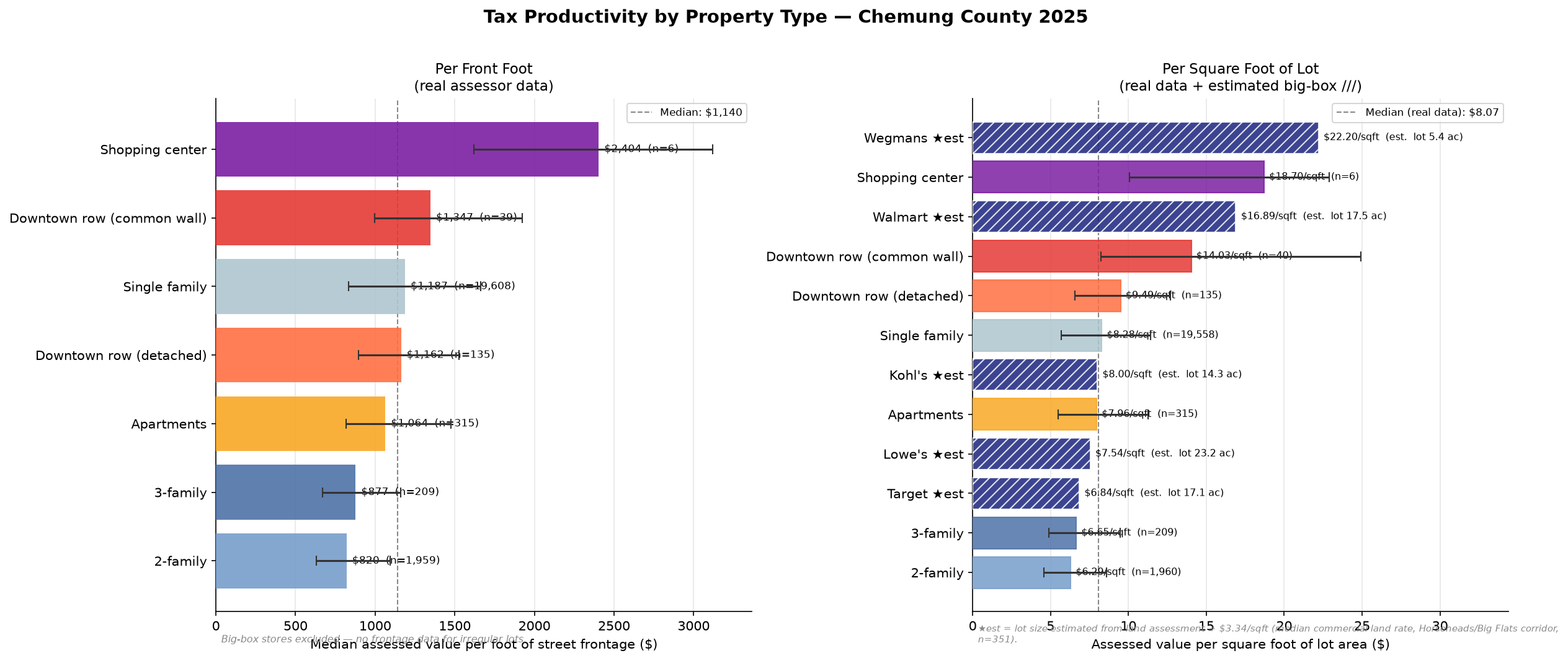
The per-front-foot metric captures this: divide a property's
assessed value by how many feet of street it faces. Higher means the property
is doing more fiscal work per foot of infrastructure committed to serve it.
What the Data Shows
Assessed value per foot of street frontage — by property type:
$2,404Shopping centers (6 parcels with frontage data)
Estimated assessed value per square foot of lot — big-box stores:
These stores have irregular parcels with no measured dimensions in the assessor records.
Lot size estimated as land assessment ÷ $3.34/sqft, the median commercial
land rate from 351 nearby parcels in the Route 17 corridor that do have measured dimensions.
$16.90Walmart — est. ~17.5 ac lot assessed $12.9M total
$8.00Kohl's — est. ~14.3 ac lot assessed $5.0M total
$7.54Lowe's — est. ~23.2 ac lot assessed $7.6M total
$6.84Target — est. ~17.1 ac lot assessed $5.1M total
$22.19Wegmans (Elmira) — est. ~5.4 ac assessed $5.2M total †
† Wegmans is in the City of Elmira where land values differ from the Route 17 corridor —
its estimate is least reliable.
The nuanced answer: Downtown row buildings score ~$10–17/sqft of lot area,
and Walmart comes in at roughly $16.90/sqft — surprisingly competitive on raw
assessed-value-per-sqft. But this misses the Strong Towns point: a 17-acre
Walmart demands 17 acres worth of roads, sewer, water, and stormwater infrastructure,
all serving one tenant and one story of retail. A 50-ft-wide downtown building
stacks that same infrastructure cost across multiple floors and uses.
The per-front-foot metric captures infrastructure cost more honestly —
and there, downtown row buildings clearly win over single-family.
The bigger picture: Walmart's $12.9M assessment is real money, but it sits on land
that a grid of downtown blocks — each generating $1,000–$2,000/front foot across
dozens of parcels — could match or exceed while requiring a fraction of the road
and utility infrastructure.
Charts
Two angles on fiscal productivity: per-frontage and per-square-foot comparisons,
plus a look at how assessed value splits between land and buildings.
Tax Productivity by Property Type
Left panel: median assessed value per foot of street frontage (real data,
error bars = IQR). Right panel: per square foot of lot — real data for
most types, estimated (hatched) for big-box stores whose lot sizes were
derived from their land assessments using a $3.34/sqft corridor land rate.
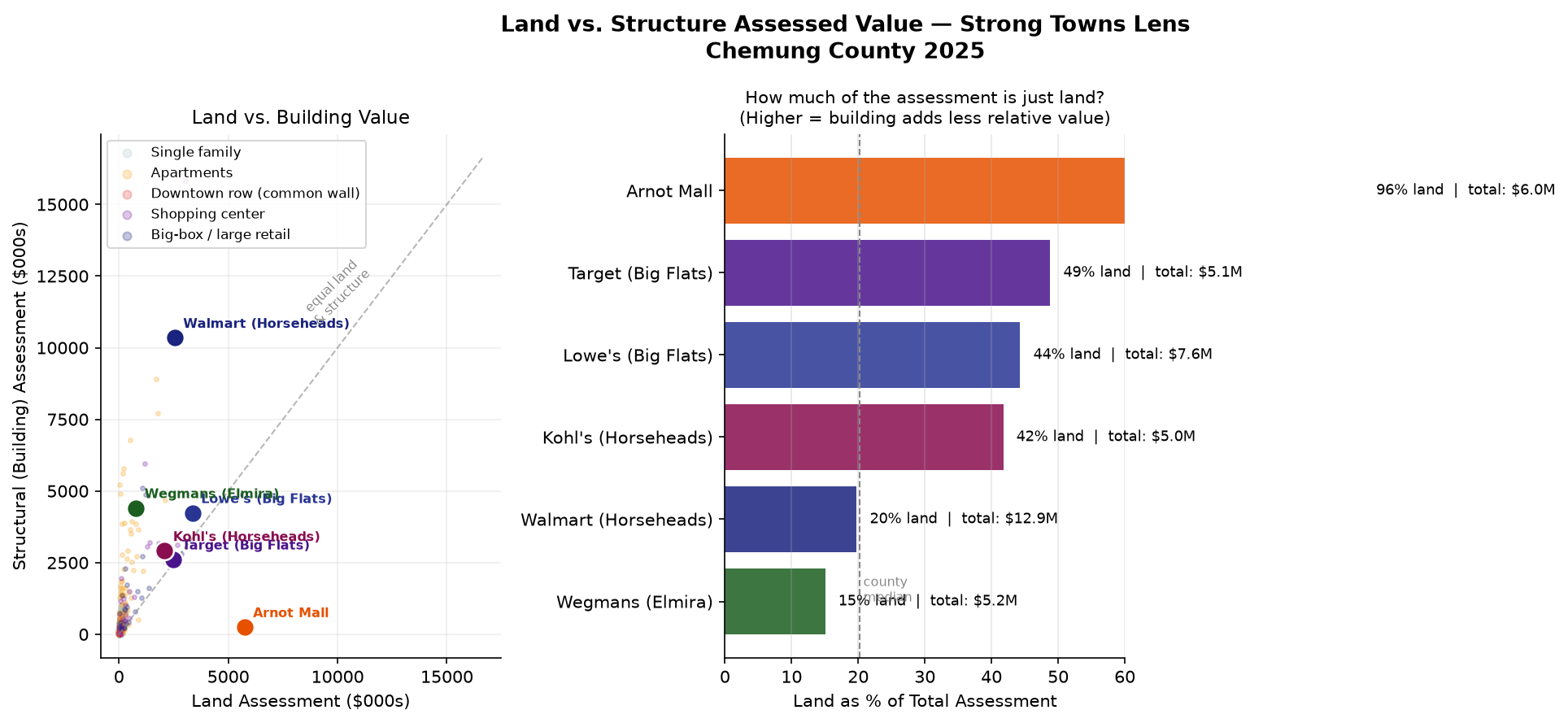
Land vs. Building Value
Left: scatter of land vs. structural assessment by property type —
properties above the diagonal have more building value than land value.
Right: for major retailers, the portion of total assessment that is
pure land (higher = building adds less relative value).
Interactive Map
All 39,321 geocoded parcels. Toggle layers to compare downtown density
against the Route 17 commercial strip. Click any parcel for full details.
Tips:
Toggle ★ Big-box spotlights to see Walmart, Target, Lowe's, Kohl's with estimated lot sizes
Toggle ★ Downtown Elmira parcels to highlight the downtown core
(929 parcels, $207M assessed)
Toggle ★ Village of Elmira Heights to see the village boundary
Use the heatmap layer to see overall assessment density across the county
Raw assessed value tells only part of the story. Several of the largest
properties are fully exempt from taxation — the county collects nothing from them.
Takeaway: 6 of the top 10 assessed properties generate
zero property tax revenue — two prisons, a hospital, a school district,
a college, and an airport. The real top taxpayers are Dominion Transmission,
CVS distribution, NYSEG, and Horseheads Real Prop LLC.